Satmap Launches Xpedition
Free online mapping, planning and sharing for everyone!
Satmap Systems Ltd, manufacturer of the Active 10 GPS, is pleased to announce the launch of Xpedition a multifunctional online mapping, route planning and sharing application. At www.satmap-xpedition.com outdoor enthusiast can find worldwide mapping, aerial photography, detailed international topographical maps and the renowned Ordnance Survey maps.
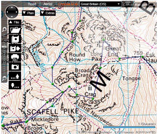
 Xpedition offers quick and easy-to-use route planning and the option to share routes and tracks with other users. It is one of the most highly featured planners, bringing powerful and unique functions to global users. Xpedition can be used on almost any computer with internet access – simply register and start planning your next adventure! Cloud based technology guarantees the super-fast rendering of maps anywhere and anytime.
Howard Dyson, CEO of Satmap Systems Ltd, commented: “Access to digital mapping anywhere and at no, or low, cost is today key. Xpedition will give users expert tools for easy planning, analysis and sharing”.
Functions & Features
Key features of Xpedition include a ground breaking split screen view allowing users to plan on different style maps and zoom levels, side by side, showing both the whole mountain and the detail of a craggy hill at the same time. A full screen mode stays true to its definition and fills every inch of the monitor. The practical snap-to-road function offers routing by keeping planned routes automatically on the road network.
Files can be saved online and are always available. The GPX file download format enables file sharing and use on most GPS units currently available. GPX tracks and routes from other sources can also be uploaded and edited. In addition to routes, points of interest (POIs), lines and areas can be marked on the maps to highlight property borders, temporary obstacles or danger zones. A search function quickly locates places, postcodes, or particular shops and helps finding the starting point of a new route. The option to print relevant statistics, such as elevation profile, route card as well as map tiles gives an extra advantage when planning and reviewing. Mobile and collapsible toolbars are overlaid on the map window and offer quick access to all these functions while giving optimal and unrestricted visibility.
Xpedition Free & Xpedition Premium
Satmap Xpedition is available in a free and a premium version. Xpedition Premium offers full functionality and access to the international topographical mapping for just £30 per year. All registered customers of the existing Satmap Online Route Planner will receive one year free access to Xpedition Premium from this launch date. New customers who purchase the Active 10 Plus or the Active 10 Bike will receive a 3 months free trial subscription.
Satmap Xpedition Mapping
Xpedition is based on the Microsoft Bing Map platform and provides full global road mapping and detailed aerial imagery. The additional map layers consist of Ordnance Survey 1:25k Explorer and 1:50k Landranger mapping for the whole of Great Britain, as well as a growing range of high quality international maps including the Alpine regions.
To find out more, please go to Satmap Xpedition
